Shaanxi Smart Agricultural Decision-Making System and Big Data Analysis Platform
Participant
Project Description:
Build a big data analysis platform for dryland agricultural systems and a "smart
orchard" decision support platform. Build a smart agricultural technology system to
support the technical requirements of disaster monitoring, early warning and
forecasting, agricultural insurance, yield forecasting, and other business departments
such as agriculture, the fruit industry, meteorology, and water conservancy.
Work Description:
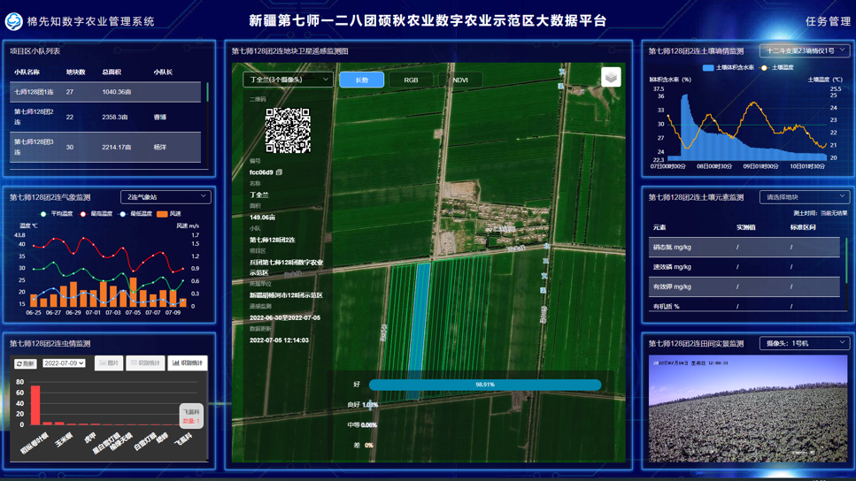
The climate data (wind speed, wind direction, temperature and humidity, precipitation,
moisture content, etc.) and growth status data (row spacing, plant spacing, plant
height, yield, etc.) of different cotton varieties during the growth period were
collected in the 12th Regiment of the 7th Division of the Kashgar Peace Corps in
Xinjiang to verify the "cotton prior knowledge" model system developed by the team and
to help the more scientific and intelligent planting of cotton.
Xinjiang Cotton Decision Management Support System
Participant
Project Description:
Build a cotton production decision management system and service platform, provide
scientific, large-scale, and standardized technical services, and realize the functions
of user/plot management, field production task management, crop growth/disease and
pest/environment/disaster prediction and early warning, agricultural means service
management, agricultural technology service management, and agricultural machinery
service management.
Work Description:
Participating in the development and design of the cotton decision management support
system can realize the management of the plots in the cotton planting area and the
decision support for measures such as fertilization and irrigation during the cotton
growth period, and provide corresponding solutions. The system needs further data
support and verification.
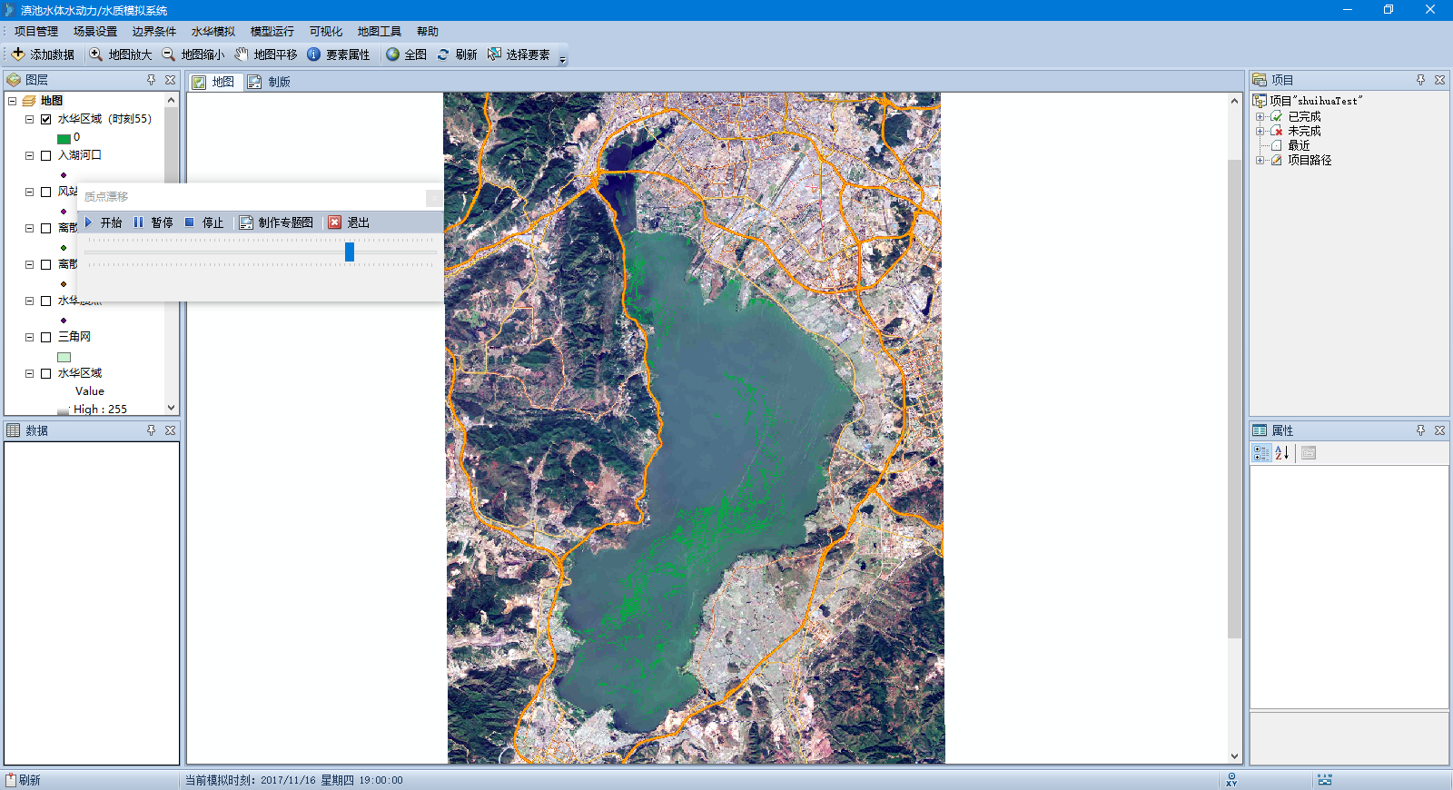
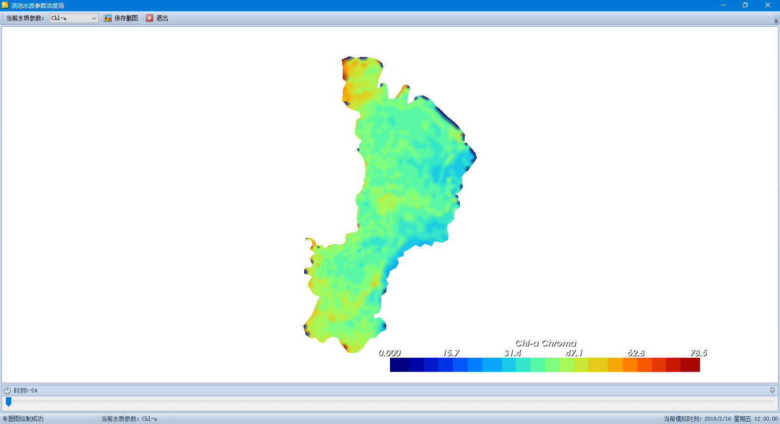
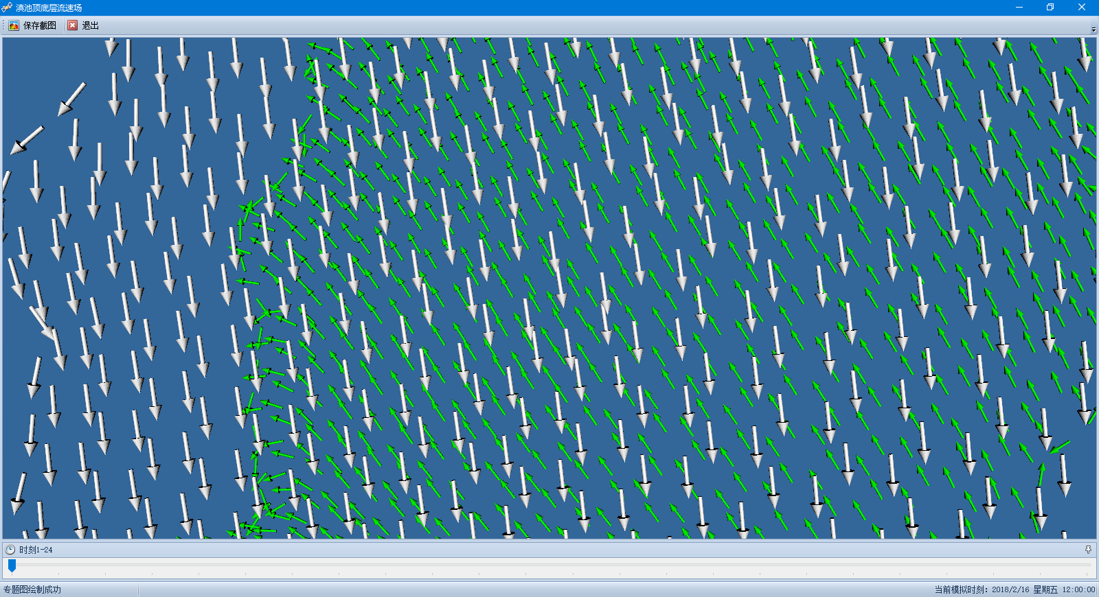
Study On Remote Sensing Monitoring and Early Warning System of Cyanobacteria Bloom In
Dianchi Lake
Principal
Project Description:
Using Fortran, C #, VTK, and
plug-in technology, based on the ArcGIS Engine platform, combined with the FVCOM model,
the spatial distribution characteristics and dynamic evolution process of blue-green
algae bloom were simulated, and the research and development of blue-green algae bloom
drift system in Dianchi Lake was completed.
Work Description:
As the principal, he completed the research on the mechanism and visualization of
blue-green algae bloom drift, simulated the spatial distribution characteristics and
dynamic evolution process of blue-green algae bloom, and completed the research and
development of the blue-green algae bloom drift system in Dianchi Lake.
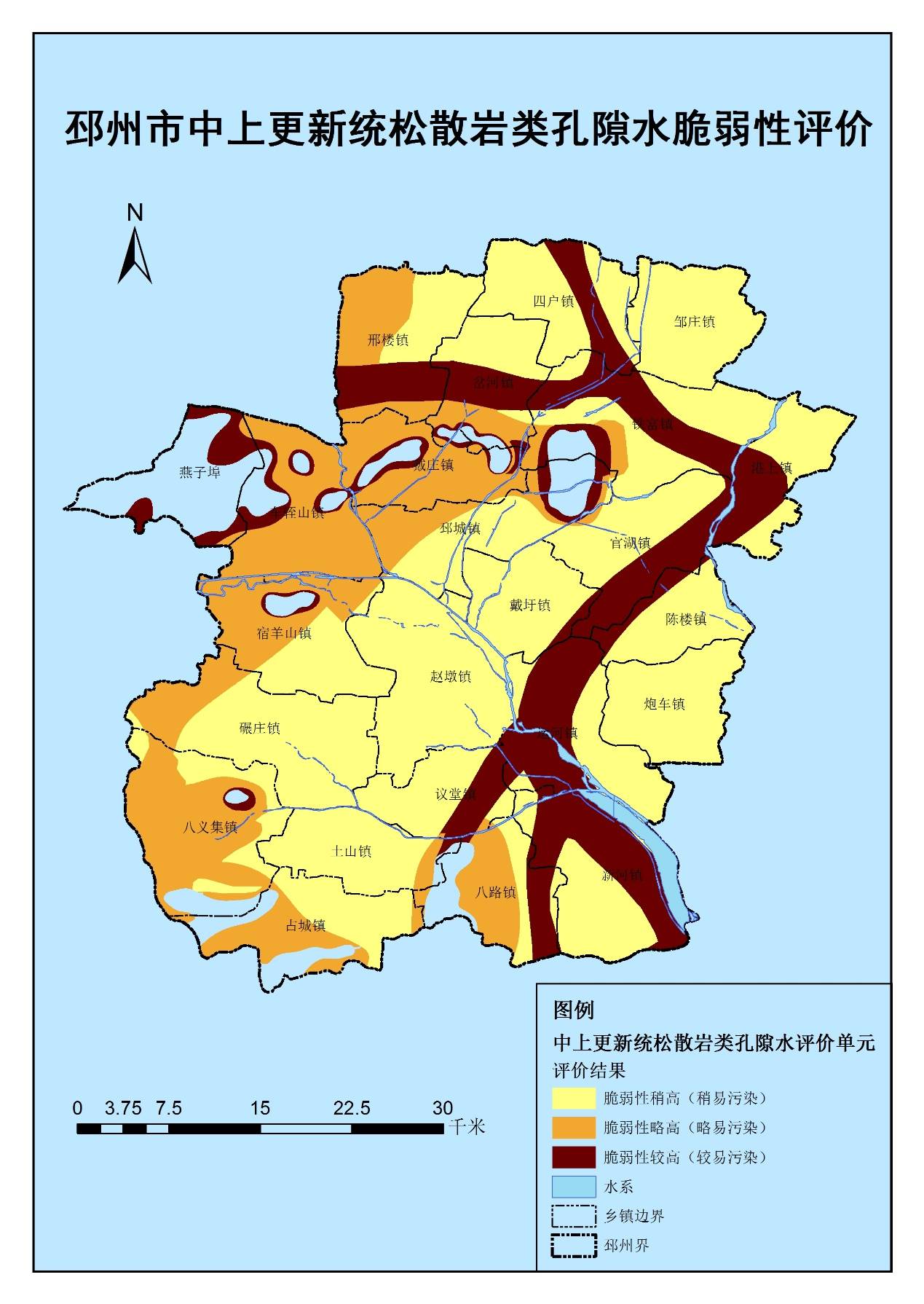
Groundwater Vulnerability Assessment in Pizhou City
Principal
Project Description:
Based on ArcGIS software and C #
development, according to the geological data, meteorological data, natural geographical
data, and other relevant data of Pizhou City, Jiangsu Province, through theoretical
analysis and regional hydrogeological characteristics, combined with expert knowledge
and experience, determine the index system and weight factor of groundwater evaluation
and complete the assessment of groundwater vulnerability in Pizhou City, Jiangsu
Province.
Work Description:
Be responsible for data
preprocessing, determining the evaluation system and weighting factors, and conducting
groundwater vulnerability assessment and mapping.
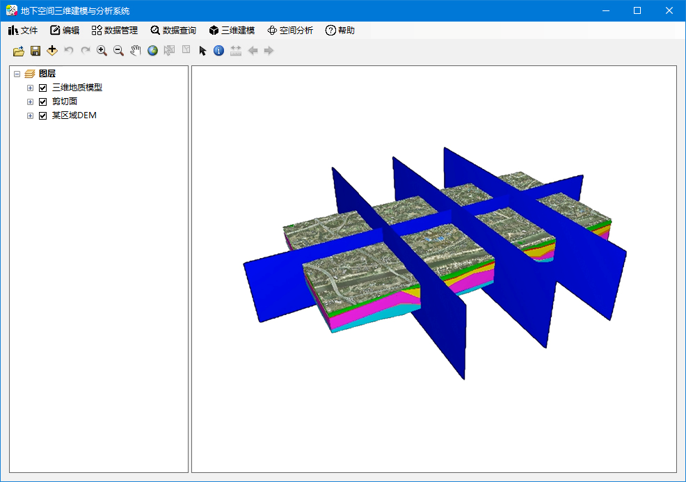
Numerical Simulation and Mechanism Study on Microtopography of Loess Slope
Farmland
Principal
Project Description:
Using the methods of artificial simulated rainfall test and microtopography scanning
measurement, the occurrence and evolution of erosion patterns in the process of water
erosion on the slope are dynamically monitored, and the corresponding microtopography
DEM is established by combining GIS technology. Through theoretical analysis and
mathematical simulation, the dynamic numerical simulation model of the occurrence and
evolution of different erosion patterns on the slope is established.
Work Description:
As the general director of the project, he made overall planning, determined the
experimental scheme, led the team members to carry out experimental research on the
evolution of slope erosion patterns of loess slope farmland, and conducted data
simulation and inspection.